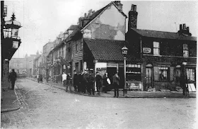
This old Deptford photo taken by Thankful Sturdey shows the west end of Creek Road at the junction of Church Street and to the left you can just see the starting of Union Street (now Albury Street). This is the junction where Evelyn Street joined Creek Road after redevelopement of the area. At the far end of the photo is the Feathers Pub located at the junction of Wellington Street, Deptford Green and Hughes Fields. On the left half way up Church Street was Queens Street. On the left of the photo you can see a wall mounted gas light. I believe this is where the Kings Head Pub once stood. The 3rd house to the right of the corner was where the Three Compasses Pub stood.
Source: My thanks to the Lewisham Local Studies and Archives

I am loving this blog and finding out more about the Kings Head Pub.
ReplyDeleteI am sorry but this photo doesn't make sense, It cannot be the Kings Head, the photo would've been taken from Church Street and right opposite would be leading to St,Nicks and the road to the letf would later become the extension of Creek Road,that pub would have been deomlished to make way for the extension. if you know the layout,you will see I am right.
ReplyDeleteSorry David your not right your wrong.
DeleteThe photo was taken from Church Street on the junction of Albury Street on the left. On the right is Creek Road. The King's Head can just be seen on the left with the lamps on the walls. The end of Creek Road was demolished as we're all the houses going up on the right tof make way for the connection with Evelyn Street further up the street.
OS map from mid 1890s
ReplyDeletehttps://maps.nls.uk/geo/explore/spy/index.cfm#zoom=19&lat=51.48118&lon=-0.02330&layers=163&b=1&r=63
From the map you can see all three pubs mentioned - Kings Head (bottom left), Three Compasses (on the right) and Feathers (at the top).
Thanks Barry for the link.....a great tool having the overlap from old to new areas.
ReplyDeleteRegards
Andy